

The Gala Heritage Trail
In partnership with the Kirkliston Heritage Society
With support from the Kirkliston Heritage Society members alongside the Gala Committee we're proud to announce the creation of the Gala Heritage Trail. The hard copy leaflets can be found in the Library and the Community Centre and this page includes further points of interest which can be used alongside the map.
We hope you enjoy walking through 100 years of the Gala!

Welcome
The Gala Heritage Trail - The Nursery and Community Centre
Points 1 and 2
Our starting point is the Nursery/Community Centre at Loanhead. Built in 1861, it was originally a Free Church of Scotland School which then became a parochial school in 1873, thus becoming the public school* of Kirkliston. It was the starting point of the very first Kirkliston Gala Procession in 1924, but there was no crowning of a Gala Queen in that year. The clock on the gable end was erected in 1912 in memory of Alexander Glendinning, Chairman of the School Board who meet an untimely death after being struck by a horse during a point-to-point meeting at Oatridge Agricultural College. In 1905, the east room was added by John McKean, son of Robert, dyker at Newliston who became a building contractor. He stayed at Myrtle Cottage, Newliston Road. John was also a poet.
In the distance, towards the northeast once stood Almondhill Farm. It comprised Catelbock, Loanhead and Meadows which were small farms. Tenanted by the Allison family - William Allison was a JP and Elder of the church. During the First World War he served in the Lothian and Border Horse, (a Yeomanry regiment and part of the Territorial Army.) He was a Director of John Swan & Co, Auctioneers. He farmed potatoes, turnips, wheat, oats, barley and hay. Allison Place (in the Boland housing estate, built c. 1972-73), is named for the Allison family. Across from the school was Loanhead House, home of Dr Peter Stewart (1882-1945). This site is now occupied by Stewart Place in the Boland housing estate. Further down was the home of Charles Gordon, (the Cruelty Man) who was employed by the SSPCA. From thereon are the ‘steel houses’, built in 1927 and now clad in brick.
* It appears that Kirkliston had a schoolmaster before 1646, the first recorded headmaster being Robert Lauson in 1663. A school was also opened at The Square in 1811 and subsequently closed in 1830.
1
2

1

1

2

2
2
The Gala Heritage Trail - The Old School House, The War Memorial & Scotmid
Points 3, 4 and 5
Next door to the Nursery/Leisure Centre is the former Schoolmaster’s house, 14 Queensferry Road. The current owner, Geoff Crow has carried out extensive renovations and improvements to the property, during the course of which a hitherto unknown well was discovered in the grounds. This has been thoughtfully restored and is now an interesting additional feature of the property.
The top floor of the adjoining property, 12 Queensferry Road was the childhood home of Bobby Moncur, former captain of Newcastle United and Scotland. Bobby moved there at the age of 9 in 1953. He relocated to Newcastle when he was 15 after being signed by the club.
The war memorial at the crossroads, designed by John Jordan, was commissioned by the people of Kirkliston in 1919 and completed in 1920. The actual site was graciously donated by Sir John Stewart Clarke of the Dundas Family. Amongst the names recorded on the monument, Private Robert Watmore was an 18-year-old whose military service ended tragically after a mere 6 weeks when he was the sole casualty of a German bomb dropped on the town of Whitby, Yorkshire. His cousin, Betty Hamilton (née Watmore), resides in Kirkliston and is a member of Kirkliston Heritage Society. She could rightly be deemed the ‘village historian’ with her encyclopaedic knowledge and photographic record of Kirkliston over the years.
Across the road, Scotmid Coop has seen various guises: Hillwood Cooperative; St Cuthbert’s Cooperative. A grocer, haberdashery and a butcher were all part of the Hillwood Cooperative. Kirkliston once had many such small shops and businesses in an age when folk did not have the time or means to travel further afield.

3

4


5
5
The Gala Heritage Trail - Station Road
Points 6 and 7
Proceeding down Station Road, which was once a tree-lined avenue prior to road widening in the early 1970’s, residents of years past would have seen a continuous line of private and business premises on the left. Next, there were public toilets and Linn’s sweetie shop which had a coal merchant to the rear of the premises. In 1939 the next two cottages were demolished to make room for the street, Almondside.
At Station Cottage (No 17, previously named Ashton Cottage) lived Mr Aitchison, the postie and lollipop man. The premises behind the bus stop (Nos 19-21) now occupied by a wool and crafts shop and funeral director were once McPherson’s the tailors. He had a ‘cheeky’ advertising slogan which read: ‘McPherson’s trousers down again – come in and have a look!’ These premises later became the District Council and Registry Office and still later, a hair salon. Further down at Nos 27-29 was Sunny Bank café and shop. The last of the old buildings on this side of the road were, for a considerable period, the only three-storey buildings in the village.
Down the right-hand side of Station Road from the traffic lights once stood a continuous high wall which almost reached what is the library today. A fishmonger, butcher and hair salon once traded to the right of the block of flats. Harold Burbeck’s grocery store adjoined what is the library today. Later, his niece Margaret took over the business until it was demolished to make way for flats (which are precariously close to the library, and thereby hangs a tale!) Margaret and her husband Arthur now reside across the road in what was Linn’s Sweetie Shop. Other business premises on this side of Station Road included an electrician and Murray’s bicycle repair shop. At one time there was even a thatched cottage further down the street
The car park which adjoins the library was once a children’s playground. It had a maypole and a small shed in which the bairns could shelter during inclement weather. This was also the start and finish point of the Gala Day Village Race which was held on Friday evening before the gala. Adjacent to that, the adult and children’s Fancy Dress competition was held at the same time. Behind the playpark a small market garden (Finnie’s) was situated in what is now Kirkstyle Gardens housing. A part-time branch of The Royal Bank of Scotland was housed in the bowling club building which is in our immediate view.

6

6

7

7
The Gala Heritage Trail - The High Street
Points 8 and 9
We have now reached the junction of High Street, Station Terrace and Station Road. Kirkliston’s first police house was located at No 3 High Street. On close examination it is still possible to make out the words ‘Police Station’ on the lintel above the door. Around the back of the premises the former police prison cell is now a garage, but its steel-barred window reveals its former purpose! The Police Station moved to 2 Manse Road in 1952-53.
High Street was the original road from Edinburgh to Linlithgow. From the east, the road entered the village where Auldgate is now. From the west, the road came from Linlithgow via Winchburgh and Niddry, emerging where Gateside Road now stands.
Further along, 11 High Street was the village newsagents owned in turn by Boaks and then Rarity. At one time there was a well outside. This block of cottages from 11 to 17 (Amulree) was built in 1805, the same year as the Battle of Trafalgar, when Nelson’s fleet defeated the combined French and Spanish Fleets during the Napoleonic Wars.
6
6

8
The Old Jail House at the rear of the Police Station


8
8


9
9

9
The Gala Heritage Trail - The Free Kirk
Points 10, 11 and 12
Across the road was a row of houses and on the corner was Dalrymple House* (stone inscribed 1761 with the initials RT and BM, Robert Taylor and Bessie Meikle - both are buried in the old cemetery). There was also Blakes’ bakery (Hillwood Cooperative) which later became the Co-op, while round the back were stables for the store horse. Purdie Carmichael, who had a fruit cart, also stabled his horse there. These premises were demolished in 1956. Set in the wall surrounding the Free Kirk stood Marshall’s Well, presented to the village in 1867 by Robert Marshall to slake the thirst of horses that has just trudged up Path Brae. Born in the Backlands** of Kirkliston, Robert was a tenant of Gateside Farm and a well-known benefactor of the village, often giving a bag of coal to the needy. The well was more obvious prior to the road widening in the early 1970’s when the Edinburgh road was closed due to theextension of the runway at Turnhouse.
Cobblers Close is so named as Paterson the cobbler made and repaired shoes there (No 21, Authurlee). It later saw service as a TV repair shop run by a Mr Webster.
Apart from the church, Castle House (Nos 25-27) is the oldest building within the confines of the village. It was the principal inn of the village and is a listed building. Inscribed on the lintel above the door is the date 1682 and the initials IF and ID* (John Findland and Janet Dick). The house was the first staging inn for the stagecoach on the Edinburgh, Linlithgow and Stirling route. Royalty, including Queen Victoria, would have paused here while fresh horses were hitched from the stables at the rear of the premises. However, more is known about the visit of the bard Rabbie Burns who stayed the night on 24 August, 1787 at the start of his Highland Tour with William Nicol, Latin master at the High School of Edinburgh. A window had 4 lines of verse scratched on it by the bard - this was later sold to a museum in Canada. It read:
The ants about a clod employ their care
And think the business of the world is theirs
So waxen combs seem palaces to bees
And mites conceive the world to be a cheese.
This year is also the 200th anniversary of an audacious robbery. In 1824, the equivalent of £300,000 in banknotes was stolen from the Linlithgow to Edinburgh mail coach whilst changing horses at Castle House. None of the perpetrators were caught and convicted and the money was never recovered!
* Cardinal Beaton (1494-1543) resided in Dalrymple House. Important meetings were held there in 1543 for churchmen and Catholic Lords who were wrangling over the Regency of the infant Mary Queen of Scots and the demands of Henry VIII who wanted a marriage between his son and the infant Mary.** Also known as the ‘Homies’ and where numerous weavers plied their trade. The area around the bowling green now occupies that site.

10
Original south entrance to the Free Kirk, adjoining Marshall’s Well

12
6
The Gala Heritage Trail - The Glebe
Point 13
Looking across to The Square, what is now an empty space once housed an ancient Court House named Barony House before being sold in 1809. The Square also variously housed a parochial school, milliners, dance school and saw service as the market place of the village where a cattle fair was held. Across the top of The Square ran a line of shops and the main entrance to the kirk grounds. This was relocated to the east when it became necessary to build a guardhouse due to the predations of body snatchers such as the infamous Burke and Hare. In 1818, the bodies of Isabel Robertson, a young widow who died in childbirth, and Widow King, a woman over 80 years were taken. The timbered houses to the right were once distillery houses and a grain store was also located there. Queen Ann House at the top of the east side was the home of Betty Hamilton’s grandparents. The last remaining building in the centre of The Square was demolished in 1931. The north side of the square was the site of the Court Hall of Regality of Kirkliston before becoming a school in 1811. In the 20th Century it became Grieves’ grocer’s shop. The old entrance to the Kirkyard stood to the west of the shop but was closed up in 1822. The house at the bottom of the west side of The Square was demolished in 1967. Unfortunately, a sundial there dated 1677 was also destroyed.
At Station Cottage (No 17, previously named Ashton Cottage) lived Mr Aitchison, the postie and lollipop man. The premises behind the bus stop (Nos 19-21) now occupied by a wool and crafts shop and funeral director were once McPherson’s the tailors. He had a ‘cheeky’ advertising slogan which read: ‘McPherson’s trousers down again – come in and have a look!’ These premises later became the District Council and Registry Office and still later, a hair salon. Further down at Nos 27-29 was Sunny Bank café and shop. The last of the old buildings on this side of the road were, for a considerable period, the only three-storey buildings in the village.
Down the right-hand side of Station Road from the traffic lights once stood a continuous high wall which almost reached what is the library today. A fishmonger, butcher and hair salon once traded to the right of the block of flats. Harold Burbeck’s grocery store adjoined what is the library today. Later, his niece Margaret took over the business until it was demolished to make way for flats (which are precariously close to the library, and thereby hangs a tale!) Margaret and her husband Arthur now reside across the road in what was Linn’s Sweetie Shop. Other business premises on this side of Station Road included an electrician and Murray’s bicycle repair shop. At one time there was even a thatched cottage further down the street!
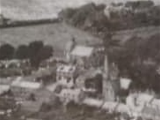.png)

Although somewhat indistinct, it is possible to make out the old Courthouse Building in The Square
13
6
6
The Gala Heritage Trail - Path Brae & Pikes Pool Distillery
Points 14 and 15
Kirkliston Church was built in 1196 and dedicated in 1244 by the Bishop of St Andrews. (Current minister - Eric du Toit.) It was built to a Norman design, with a western tower, a nave for the congregation and a chancel which no longer exists. The south doorway, with its Norman arch, was closed off in 1822 when an aisle was added on the north side of the nave to accommodate the growing congregation. The pulpit now stands on the inside of the former south entrance. The north entrance to the church was eventually superseded by an entrance to the east, which remains the main entrance to this day. A model of the church showing this layout can be seen inside. The (Catholic) first Rector was William de Kinghorn - appointed by Pope Martin V – and he swore fealty to Edward I of England in 1298 (In all probability he didn’t have much choice with an English army on its way to the Battle of Falkirk camped nearby!) The layout of the church was altered in 1560 (during the reign of Mary, Queen of Scots, when the Catholic Church was declared illegal) by adding a chancel to either side of the nave. The first Scottish parliament was held in the church in 1235, overseen by King Alexander II.
The Free Church across The Square was constructed in 1843 soon after the Disruption in the Scottish Church. A spire was subsequently added in 1880 as a memorial to James Maitland Hog. The original south entrance was in High Street with a decorative iron arch and paraffin lamp above it. The two congregations merged in 1942 and the Free Church premises are now the Thomas Chalmers Centre. The pulpit now stands on the inside of the former south entrance. The north entrance to the church was eventually superseded by an entrance to the east, which remains the main entrance to this day.
As we descend Path Brae, the area of trees and bushes on our left was once a line of distillery houses, the topmost of which was for the distillery manager. About a third of the way down on the right-hand side is a recess in the wall where there was a well for horses coming up Path Brae.
The sprawling distillery complex which lay at the bottom of Path Brae was first established in the 18th century and was a major employer in the village. After a devastating fire in 1914, the complex was re- purposed as a maltster before its demolition in 2006. A single Still Tower has been preserved and is now a private dwelling.

15
🚨 BE CAREFUL YOU ARE ABOUT TO CROSS A BUSY ROAD! 🚨

15

15
The Gala Heritage Trail - Manse Road & The Main Street
Points 16, 17 and 18
Back in 1924, the gala procession would have branched off to the right upon reaching the bottom of Path Brae and proceeded up Lambs Mill or Back of Mill which was a throughfare leading to Manse Road at that time. Lamb’s Mill once stood here to produce grain along with a small farm (Clarke’s Farm). As we reach Manse Road, the fine-looking house (No 22, Fernbank) belonged to the Distillery Manager, David Denholm. On the right are the Glebe houses – built 1965 – on what was the original Church Glebe, the first venue for Kirkliston Gala. It was a most picturesque site with a burn running north-south through it. The burn on occasion tries to re-assert its presence, evidenced by the periodic flooding in the area!
Manse Road is so named for the manse set amongst the trees on the right. Built in 1865, this was Kirkliston’s second manse, the original being demolished in 1866 to make way for the new churchyard. At one time, the Minister, Rev Adam Tait, got into trouble as he used a track between the church across The Glebe to the Manse to avoid paying a toll! The third house (Rosedene, No 16) on the left was the home of Kirkliston’s original vet, Mr Mackie. At the far end of Manse Road, the last house on the left (No 2) was Kirkliston’s last police station opened in 1952/53 and closed around 1980/81.
Houses known as the Brankin and belonging to Newmains Farm once stood on what are now small memorial garden areas at the junction of Manse Road and Main Street. Main Street has been variously known as High Road and Market Road before the present name was settled upon.
We are now on Main Street which has undergone many changes through the years. The large houses on the left were yet more homes for distillery employees whilst The Old Post Office cottage (No 11), so-named on the left was indeed once a Post Office for over 100 years. The Post Office was relocated to No 66A across the road. On the right, the chemist once housed Miss Leggatt’s ‘The Cozy Tea Room’. There was also a Reading Room to the rear where Nippers Nursery is located, offering billiards, cards, dominoes etc for the villagers between the years 1906 and 1938.
Main Street Contd.
Points 19, 20, 21 and 22
A garage (Forrest’s) and then a pub (Forrest/Proven) once stood where ‘Leaps and Bounds’ nursery is now. On the opposite side of the road, Number 66A was our village Post Office until 2015.
The dental surgery (No 17) has variously been a shop (Kennedy’s), a ladies’ school and the Masonic Lodge. Next door was the village chemist (George O Andrews) at one time. The Kirkliston Community Church building was once the Masonic Lodge until 2007.
Next to the Newliston Arms was once a dairy (Arbuckles at No 66, Dairy Cottage). Cows would be herded from down Foxhall to be milked two or three times a day. This daily ritual resulted in a profuse deposit of ‘skitters’ on the road, a malodorous obstacle course for pedestrians!
The present Newliston Arms is a listed building and dates from 1865. Prior to that, it was a two-storey building. An original hand well still exists in the back of the premises. The Upper Toll booth stood to the east of the pub.
The Fourways Fish Bar was once a dance studio, then a café. The Bewitched Salon premises in the past have seen service as a fish and chip shop (Marandola’s), greengrocer, video hire shop and an antiques/bric-a-brac store whilst the Lucky House Chinese takeaway (No 35) has been an ice cream shop, sweetie shop (also Marandola’s), hairdressing salon and dental surgery prior to its present incarnation.

18


18
19

20

22

22
You have now reached the end of the original 1924 Gala Procession route.
6
The Gala Heritage Trail was made possible thanks to funding from the National Lottery Heritage Fund, and with support from the Kirkliston Heritage Society in conjunction with the Kirkliston Children's Gala

